|
| Ford Church |
Some years ago while idly perusing my local Ordnance Survey map I came upon a footpath near Barnham (about twelve miles from Worthing ) labelled ‘old canal’. I had never before realised that an old canal had existed in this part of Sussex
 |
| Ford Lock Keeper's Cottage |
As with all the other canals in Sussex , the Portsmouth Portsmouth from London
 |
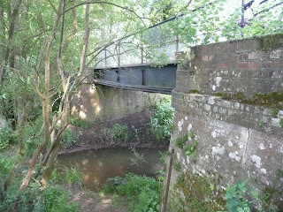
| Ford Canal Junction |
I had intended to park at Ford station and get the train to Chichester to start my walk, but a full car park put paid to that idea. I instead pushed on to Yapton, about a mile and a half away. This meant that I could get the first part of the walk under my belt before the train journey. I experienced no problem parking there, but any notion that I might find any trace of the canal through the village were soon squashed when I quickly realised that it would have headed across what is now the main recreation ground and then through the adjacent housing estate. I wonder how many local people are even aware that a canal existed here? Once I had cleared the built up area of the village I did get a tantalising glimpse of the old route, although it was very weed-choked and was actually not much more than a linear depression for about 200 metres. I had a feeling that most of the route was probably like this and yet it whetted my appetite to find more interesting relics. After this very short section the remaining part of the route across to Ford basin had been obliterated by the former World War II aerodrome, now also closed and serving as an industrial estate around the perimeter of the runway. It was a fairly uninteresting walk around the perimeter of the old airbase but as I reached the Ford-Arundel road I noticed a house that suggested that it was once a lock-keepers cottage. I guessed because it seemed to be a similar style to those I had seen on the Wey and Arun. This particular one had a depression running through the garden suggesting the presence of the old canal by its side. It also struck me what a desirable residence it now was, a far cry from its humble origins.
 |
| Chichester Basin |
Just across from the lock keepers cottage is Ford Church , small but very old (Norman Ford Basin
 |
| Poyntz Bridge |
A pretty unfriendly dog in one of the houseboats helped me push on rather than linger too long. Sadly there is no footpath connection from the riverbank to Ford station and so I had to make my way there via the road, which wasn’t the most pleasant of walks. Fortunately I didn’t have to wait long for the train and about fifteen minutes later I was in Chichester for the start of my walk proper.
 |
| Chichester Ship Canal |
I made my way down to the canal basin that once served as the main docking point for ships that had traversed the Chichester Ship Canal
 |
| Looking Back to Chichester |
Hunston was once a canal junction and marks the point at which the Portsmouth and Arundel Canal met with the Chichester Ship Canal
 |
| Hunston Bridge |
From Hunston I can’t say that the next mile was particularly enjoyable as I had to largely follow the road through North Mundham and Runcton. Alongside the road I could clearly see portions of canal bed, some even in water. However, the pavement seemed determined to keep me on the opposite side of the road and with fairly heavy traffic using it I wasn’t in much of a mood to cross and have a closer look. If you come this way it might be worth considering an alternative route to the south of the villages and well away from the road.
 |
| Runcton Chapel |
At Runcton I turned left onto a country lane and came across another clue of the canal’s existence. This was one of those where imagination was important for the clue was no more than a slope on the road where the canal bridge would once have been but has long since disappeared. This was only really noticeable because of the otherwise extremely flat terrain around these parts. All traces of the canal route across the field adjacent to the road had completely disappeared and I had a feeling it might be some time before I saw anything else.
 |
| Maket Gardening |
Yet, a couple of surprises cropped up as I headed towards the hamlet of Merston. The first was a glimpse of a canal bridge in remarkably good condition way across the field next to the road. Sadly this would be the best view I would get, since there was no footpath to it and I couldn’t get any closer. The second was the small church of St Giles
 |
| Restored Section at Lidsey |
A little further along the road and I was relieved to put the tarmac behind me and return to the towpath, now well away from roads. I knew I had reached it when I came across the remains of a former bridge although in this case it wasn’t much more than a fragment of wall. For the next 2-3 miles the walking was a bit dull for although I was undoubtedly on the former towpath there was no canal to be seen, only fields full of soft fruit, polytunnels and migrant workers still picking strawberries despite the fact that we were by now well into the evening.
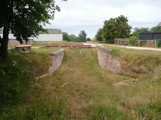 |
| Lock Remains |
As I approached Lidsey the rain returned and for a few minutes I actually got quite wet. The rain made quite a racket on the polytunnels next to me but none of the workers inside seemed to mind. I was relieved though when I finally passed the last of the strawberries as their sweet fragrance was beginning to make me feel quite hungry! At the last polytunnel I finally came upon the canal once again and for the section past the old Lidsey Landfill it was actually quite well-restored with towpath and dry canal bed running side by side for about a mile. I guessed that keeping the canal bed free from weeds helped with the monitoring of methane emissions from the now closed landfill site. For me though it was a bonus after the miles of not seeing much so far.
 |
| Restored Section |
At Lidsey I reached the A29 and noticed the kink in the road that was provided for the canal crossing, now of course no longer needed. The canal continued straight across and the footpath followed a service road for some distance. I soon realised its purpose when a skip lorry came up behind me, forcing me to take refuge in the adjacent bramble bushes and stinging nettles! Its destination was soon apparent by its smell long before I got there – it was a sewage works. Its rural location meant that deodorising equipment was less necessary than elsewhere and it hummed terribly! A short distance later I crossed the Bognor branch railway line and entered the last and most interesting leg of the route past Barnham and on to Yapton.
 |
| Sun Makes An Appearance |
This section has been the subject of archaeological excavation, which has revealed the remains of the swing bridges that were provided to help cross the canal. The canal bed has been dug out and kept free of growth, helping the walker to visualise what it must have looked like when operational. I’m not sure if there is any long term plan for restoration, but this would be a far more ambitious prospect than the Wey and Arun. Nevertheless, I enjoyed this part of the walk more than any of the rest which was a happy result of my parking problem earlier in the day. Walking the last bit to Ford after this would have been a little soul destroying. I also had the benefit of a little sunshine at last as I reached Yapton, which made the view of Barnham windmill a few hundred metres to the left that bit more special.
 |
| Barnham Windmill |
There was one last surprise from the canal when I reached Yapton. On the edge of the village a small housing estate had been built (I am guessing in the 1980s) right across the canal bed. This was now the access road through the estate and yet a perfectly preserved former canal bridge had been incorporated into the development. I discovered later that it is grade II listed, which probably made knocking it down a complete no-no for the developer. It now makes for a rather incongruous centrepiece for the estate! It made for a fitting place to end the walk, with my car just a couple of hundred metres further on.
 |
| Yapton Bridge |
I thoroughly enjoyed discovering this lost transport relic although in truth there are a lot of dull sections in between the more interesting parts of the canal. I think that if you are more interested in the history than the walk a shorter circular route around Barnham and Yapton ought to capture most of the main highlights of the route. However, if you have 3-4 hours to spare it is worth doing the whole thing if only for the solitude you will get! I met only about half a dozen people on the whole route, excepting the boat load at Hunston which was a fluke.