 |
| Setting Off |
Sometimes I am in the mood for a
walk that is purely all about the views and doesn’t necessarily provide lots of
historical or natural interest. The Downs to the north of Worthing are definitely a case in point. Largely
devoid of trees or landmarks there is nevertheless an overwhelming feeling of
space and freedom and this latest walk was definitely out to capture as much of
that mood as possible. This is walk 4 from the Pathfinder Guide volume 52
‘More Sussex Walks’, rather misleadingly called ‘Cissbury Ring From
Findon’. I say misleadingly because the walk actually starts from the car
park at the top near to Cissbury Ring and more than a mile from Findon.
 |
| Dewpond |
My girls joined me on this walk as
they were anxious for some fresh air too after a week of being cooped up
indoors courtesy of the wet weather. Today was a different prospect – big
skies with puffy white clouds billowing across the landscape and lighting which
showed off the South Downs at their very
best. From the car park we headed due east, not a direction we normally
go from here. The chalky path was surprisingly tricky underfoot due to
the rather jagged looking flints that poked up to provide some rather nasty
tripping hazards for anyone not paying attention.
 |
| Hawthorn Berries |
Along the path was a very wintry
looking landscape becoming rather devoid of colour as the lushness of the
vegetation has diminished considerably. A few of the hawthorn bushes were
manfully hanging on to their red berries but the early lustre of shiny autumn
fruit had been replaced by matt versions… The girls wandered along behind
me chattering to themselves leaving me to admire the landscape and the
magnificent clouds.
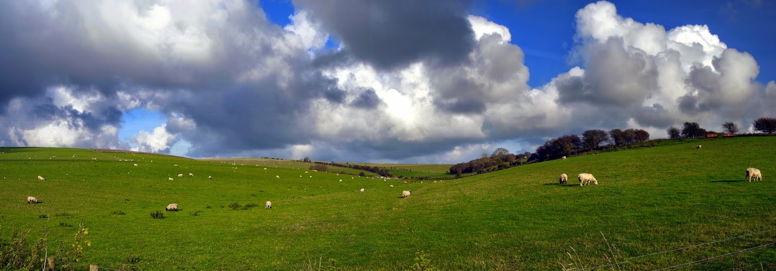 |
| Magnificent Clouds |
At Stump Bottom we paused briefly
to take a look at a rather interesting looking dewpond. I have never
really understood why they are called dewponds, for they cannot be fed by
dew. What is indisputable though is that they are vital on the dry
landscape of the South Downs. Water
cannot normally collect on the Downs as the
underlying chalk is so permeable. The days of the dewponds wholly
servicing the refreshment needs of livestock are gone though and many,
including this one, have become mini-ecosystems in an otherwise alien
environment.
 |
| Lychpole Farm |
We pushed on to the crest of the
hill and then took a turn down to the right into a valley now occupied by
Lychpole Farm. This rather well appointed farm is tucked down into one of
the dry valleys of the Downs and judging by
the size of the farmhouse I would suspect that the original farmer did quite
well for himself. As we headed down into the farm we passed the only
person that we met along the whole route before the end at Cissbury Ring.
Given that this was a Saturday afternoon with pleasant weather it was perhaps
surprising that there were not more people about.
 |
| Farm Equipment |
Once through the farm we wandered
along a tarmac road through to Beggar’s Bush admiring the array of farm
machinery that was in evidence as we did so. Before reaching the main
road we headed off on a track that took us to the foot of Lychpole Hill.
This is where the mud started in earnest! For the next mile or so it was
a struggle as we picked our way through the brown stuff in what is clearly a
bit of a frost hollow. There was no sign of the sun as we wandered along
in the shadow of the hill. It was also evident how tight the loop of
walking is as Lychpole Farm almost looked within touching distance.
 |
| Into the Trees |
After walking across a field that
seemed to go on forever the path then passed into the woodland alongside Tenants
Hill. The underfoot conditions didn’t really get any better as we passed
through the largely damp woods. The trees had largely lost their leaves
now and much of the understorey within the woods was dominated by old man’s
beard and various other dead looking weedy plants. Sadly there were no
fungi even though we looked hard to find some.
 |
| Looking Back to Lychpole Farm |
The path eventually came out at
the ramparts of Cissbury Ring, our local beauty spot and much loved place to
walk. The official route would have had us walk to the centre of the old
fort and then down to the car park from the trig point. For us though we
could not go to Cissbury Ring without walking the ramparts – that is the best
part about visiting! Whenever we come we always muse about what life must
have been like for the hardy souls that lived up here in 300BC. On a cold
day like this it must have been very quiet with most of the inhabitants
hunkering down in their huts with a big fire going. I suspect though that
the location would have been surrounded by trees so perhaps it wasn’t quite so
windswept back in those days?
 |
| Cissbury Sunset |
One of the main reasons for
wanting to walk around the ramparts is that by now the sun was setting and I am
of the firm belief that this is perhaps the best place in all of Worthing to see a sunset. The orange disc cast
wonderful light across the West Sussex coast and picked out the outline of the Isle of Wight in the distance. It was quite a treat
and a fitting finale to our short walk in our back yard.


