Sunday 18 October 2015

Tilford and Waverley

Tilford

I had a small companion with me for this walk and she was keen to visit somewhere new where we hadn't been before.  After dropping off older daughter for a weekend away younger daughter and I took advantage of being away from home to visit Surrey and thought that Waverley Abbey would make for a good focal point for our walk.  Hence we chose walk number 13 from the Pathfinder Guide volume 65 Surrey Walks.


Tilford Bridge
Our walk started in Tilford.  Unfortunately I got my bearings a little wrong and we ended up parking just outside the village which meant that we had to walk a little way before getting to the official start at the village green.  This was clearly set up for cricket but being a Friday there was no cricket today.  As with so many villages in Surrey and Sussex though all the elements of tradition were there - beautiful houses; cricket pitch; attractive pub and as we were soon to discover - a functioning village shop.  It was good to see that this corner of Surrey is thriving.
Tilhill House

As soon as we left the village green behind we crossed the River Wey by a small historic looking bridge.  This was apparently once used by monks from Waverley Abbey although I am sure the bridge has been modernised a bit since then.  We stopped briefly at the village shop for some refreshments and continued along a path at the edge of the Wey Valley where the floodplain reaches the valley sides.  It was interesting to see that there were lots of World War II relics alongside the path including pillboxes and tank traps.  The home defence must have believed that this valley would have been used by the enemy to make incursions into the English countryside.

Abbey Refectory
A little further on and we passed by the magnificent Tilhill House.  This rather handsome looking house had recently undergone some renovations by the looks of things and the finished result was magnificent.  Having finished the main house the renovators had turned their attentions to the outbuildings and I rather suspect that these were to be turned into holiday lets.  Whatever the final use there was some serious investment going into this estate.  My daughter befriended a cat here and I had to wait patiently while she finished with the stroking - that wasn't the only animal she made friends with that day.
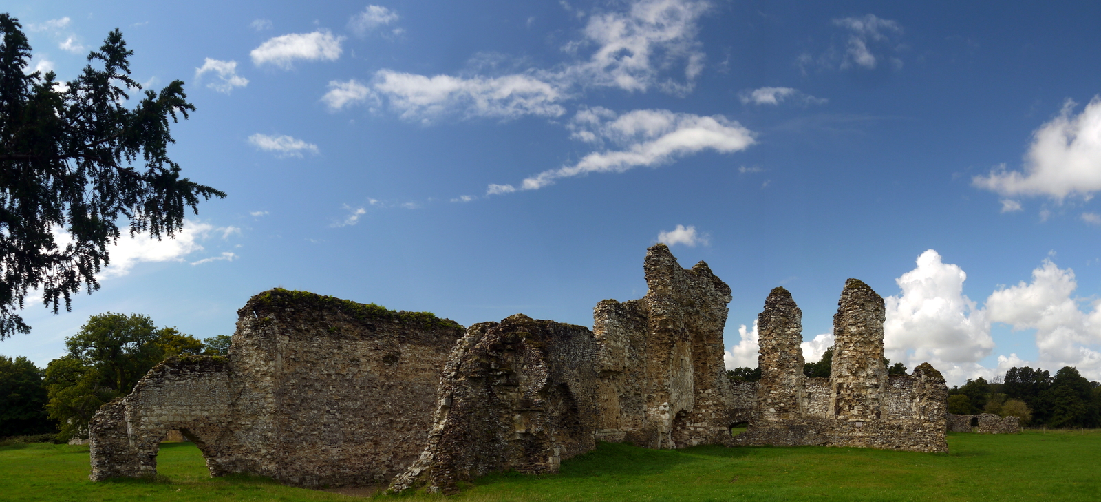
Abbey Ruins

Our onward walk continued through thick woodland and the rain of the week before ensured that some very deep puddles had formed on the path.  In fact some were so large you would be forgiven for thinking they were ponds.  They weren't at all inviting either as they were extremely black and murky looking.  Even my daughter was wary of testing one!  We were quite pleased to be past this section although what was to follow was equally unappealing albeit for very different reasons.  The path came out onto a very busy road and we had to walk several hundred metres along here before finding the entrance to Waverley Abbey.  The road did pass a rather fascinating section of weirs which were associated with the adjacent mill, although I somehow doubt that this still works.
Waverley River

We left the road and headed alongside a wider section of river, I imagine formed by the damming that we had seen by the road.  This was I imagine the water supply and source of fish for the monks at the oldest Cistercian Abbey in the country.  Not much of Waverley Abbey is left now.  Along with so many of these religious institutions it was finished off by Henry VIII in the Reformation although in truth it was already in decline at that point.  We were lucky in that our arrival coincided with the clearing of the clouds that had dogged us during the woodland phase of our walk.  We took the opportunity to have our picnic here - the walls of the abbey providing a dry place to sit instead of the wet grass that had meant our shoes were already very wet.

Crooksbury Hill
Most of what is left of the abbey is the refectory - the church has long since been reduced to the outline and fragments of wall.  I am always curious as to why it is the more domestic buildings that survive.  Is it because the stone used for them is inferior and therefore a waste of time to use elsewhere?  I imagine some of the better quality stone found its way over to the large house that has been built on the other side of the water.  We lingered for quite a while reading the interpretation boards and finishing our picnic lunch.  Even when we moved on we spent quite a lot of time by the water enjoying the butterflies and flowers.
Crooksbury Common

We then had to retrace our steps along the rather horrible road (and in fact head on a little further) before disappearing into the woods once again.  The path headed past a small collection of houses deep in the woods.  The setting looked idyllic but I am not sure I would like to live in such a place.  For me the trees moving about on a windy night would make me feel very nervous.  We crossed another road and headed uphill to a viewpoint at Crooksbury Hill.  From here we got the most amazing view south even being able to see Chanctonbury Ring, some 30+ miles away.  By now the sun had taken over completely with most of the clouds moved off to the distance.  With so many moving around though we didn't think that it would last and so made the most of our good fortune while it lasted.

Charleshill House
Our onward walk was now almost completely woodland for a good long time as we crossed Crooksbury Common.  We also enjoyed the fact that our path was largely downhill from the viewpoint.  We enjoyed plenty of chat on this stage of our walk as although the woodland was lovely there was very little of note to get excited about.  In fact we were hard pressed to even find any natural things to look at like flowers, fungi, butterflies or birds.  The next thing of note we saw was a very elegant looking house as we approached the hamlet of Charleshill.

The Donkey
Across the road from the end of our path was a pub called the Donkey and we stopped here for a drink in the beer garden, enjoying the warm sunshine as we did so.  As we sat enjoying our drinks the very kind staff from the pub came out armed with a bowl of vegetables for my daughter to feed the donkeys after which the pub gets its name.  She was absolutely delighted and soon was feeding both of the donkeys who seemed very hungry!  We stayed until all the vegetables and drinks were consumed and headed off on the last leg of our walk back into Tilford.  This was largely along estate roads and country lanes.  By now the sun had disappeared behind clouds again, meaning that we had a very different outlook on the countryside.  It was just our luck that the sun didn't reappear until we reached the car once again.  This was a short walk with a definite highlight of Waverley Abbey.  The rest was pleasant but not especially diverting.  The pub however is worth remembering for it was delightful - next time I shall aim for lunch here!

Wednesday 14 October 2015

South West Coast Path Section 43 Torcross to Dartmouth

Torcross
With these flying visits I always try to make the hardest walk first so that on the day of my return I am not too tired to drive home.  I was pleased that this next section of walk promised to be rather easier than the previous day and with only 10 miles of walking the distance was a little more modest too.  I decided that after my trip over on the Dartmouth ferry in the car yesterday that I would leave it behind at Kingswear today and get the foot ferry over and take the bus to Torcross.  I also made sure that I gave myself plenty of time today and found a parking spot at the yacht club.  When I made it across the Dart I had plenty of time for a coffee while I waited for the bus.
Slapton Ley

As I stood waiting for the bus I became aware of a very penetrating voice from a young girl talking very loudly into her phone.  I couldn't understand a word she was saying as it was in a foreign language that I didn't recognise although it sounded Eastern European.  I was horrified when she got on the bus behind me and continued her loud conversation for some considerable time on the bus.  Eventually she was told to shut up by one of the other passengers.  She took it in good grace but my goodness I have never heard anyone talk quite so loudly and quickly in all my life.  She got off at Blackpool Sands and everyone breathed a big sigh of relief and relaxed into their journey.

Sherman Memorial
I was the only person who got off at Torcross.  I suspect most of the passengers (who were pensioners) were on for the duration of the journey all the way back to Plymouth.  It was a little chilly to start with but the day soon got going as I began the walk along Slapton Sands.  This was the scene of Exercise Tiger; a World War II operation that was a rehearsal for the D Day landings but which ended in tragic consequences as German E Boats attacked the operation and the attack plus the ensuing chaos resulted in nearly 1000 American servicemen losing their lives.  Because of the utmost secrecy of what was taking place here the whole incident was hushed up until after the War and remains a footnote in history.  On the beach itself the events of those tragic days are remembered though and the focus of the memorial is a Sherman Tank that was dragged out of the water and partially restored.  It is a poignant and arresting monument - you just cannot pass by without learning more about the tragedy that brought it there.

US Memorial
The first two and a half miles of my walk today was entirely flat as I proceeded along Slapton Sands.  These are not really sands at all but are made up of shingle of varying grades.  The beach is like a small version of Chesil Beach further to the east as they trap behind it Slapton Ley, one of the largest freshwater lakes in Devon.  The beach was formed during sea level changes after the last ice age and the material is constantly reworked but not replenished.  If the beach were removed like that at Hallsands it would not replace itself and the sea would engulf the lake behind.

Looking Back Along Slapton Sands
Despite the flat terrain I cannot say it was a boring walk.  As I wandered along - sometimes on the beach and sometimes on the Ley side I enjoyed the cloudscapes; the flowers and the insect life that abounded here.  In fact the only thing that wasn't very enjoyable was the traffic that interrupted the peace and quiet regularly.

Strete 'Pub'
About half way along the beach I stopped to read the very large memorial by the side of the road.  This one had a different focus - it was there as a gift from the Americans to the people of the surrounding villages who had sacrificed their homes to be used for the purposes of military training in the early months of 1944.  Some of the houses had been blown up or significantly damaged in the process.  It is hard to believe that people would sacrifice in quite the same way nowadays.

Strete Coast
Eventually I reached the end of the beach and the road double backed inland.  My path took the route of the old road up the side of the cliff overlooking the beach.  This was a gentle climb at first and the going was quite pleasant.  The track soon opened up into one that was obviously accessed by motorised transport and became less pleasant as I continued upwards.  However, I soon learned that this was actually a new path replacing a rather unpleasant section along the main road so comfort in small mercies I think :)  I paused to look down at the beach one last time before disappearing into the woods and was rather surprised to see people wandering about with no clothing on.  I later learned that this stretch of beach is popular with naturists.  I wonder what they think of the new path that provides a grandstand view?
Blackpool Sands

Entering the woods was very pleasant as the shade really helped cool me down.  Sadly though that was short-lived as the onward path took a very steep zig-zag course up towards the A379 road high above me in Strete.  It was quite a climb to the top but I eventually came out in a field by the road.  Luckily the path does not go out into the road any longer and the onward way is quite pleasant into the village.  Strete is an agreeable little place and even the main road through it cannot spoil its charms.  Many of the houses are rather chocolate boxy thatched affairs, which probably forces prices up and means that the village is out of the reach of local people wanting to buy.  I suspect that is also why the pub on the main road has converted to a private house.  It did confuse a couple who had stopped for lunch though - they looked very bemused when they realised that the pub was no longer functioning.  I stopped in the shop which did not have much in the way of very interesting things to buy - certainly no pasties or anything remotely fresh.  I satisfied myself with a cold drink and plodded on.

Stoke Fleming Church
My onward path soon left the road and continued across fields to as near to the cliffs as I could get.  It made for pleasant walking as the airiness of the hills soon provided a fantastic view down towards Blackpool Sands.  Any notion that my path would head gently down the slope to the beach were soon scotched however when the path sharply turned a corner to reveal a large dry valley in my way.  It wasn't exactly what I wanted to see but it wasn't actually as tough as it looked.  As I plodded up the other side I was congratulated by a couple of ladies who were enjoying the view and had been watching my progress.
Speckled Wood
I crossed the road at the top and took a route away from the road down to Blackpool Sands.  This was a far more popular beach than I could have considered - it was absolutely rammed with people and although the guide book had recommended the cafe for provisions it surely did not realise that the queues would be so large?  I grabbed a bite to eat and watched people for a period of time before pushing on.  My flirtation with the the more usual type of holidaymaker in Devon was very short-lived; as soon as I left the beach area it was back to the peace and quiet of the walk.  Again I was on the climb - this time up into the village of Stoke Fleming.  The path followed through the back parts of this village and finds its way to the very large church.  I suspect the tower here was used as a daymark for it is unusually tall.

Hercules
At the far end of the village I passed through a gate from a sports field that had been put there for the Golden Jubilee in 2002 - hard to believe that was so long ago now!  On the other side of the road I headed along a lane that would form the next mile or so of the walk.  I was rather relieved that all the climbing seemed to be done for now even though the road walking wasn't so pleasant.  I was thankful that the road was really quiet and largely free of traffic for there were few places where it was possible to get out of the way of traffic without getting prickled by the roadside vegetation.
Dartmouth Shipping

At Little Dartmouth I was most pleased to leave the road behind and take a path that headed down towards the coast once more.  As I wandered down the path I became aware of a rumble of aircraft engines and looked up to see a Hercules pass within a whisker of me!  It was as close an encounter as I've had on this walk.  As I got down to the coast I could now see the end of the walk almost as on the horizon was the day mark that I remembered from the next section of the walk that I completed in 2014.

Dartmouth Castle
The onward path hugged the coast quite closely until I got into the mouth of the River Dart.  Despite it being not very far it seemed that this section took far longer than expected; partly because I was pretty hot and bothered by now.  I was most relieved to eventually reach Dartmouth Castle; one of Henry VIII's forts that was built to protect us against the threat of French Invasion.   Sadly there was no time to visit this time but I did take advantage of the shop next door to avail myself of an ice-cream that was massively welcome.  It rather helped on the last section onto Dartmouth and on to the ferry to take me back to Kingswear.  Yet there was one last surprise in store on the path as it passes through another fort at Bayards Cove.

Dartmouth
I was super pleased to get to the ferry and fortunately did not have to wait long for my crossing.  We did have to wait half way across though for a fishing boat to go by; I suspect this is a ritual that has to be performed several times per week.  It was a relief to be back to the car at a reasonable time although the walk today did take rather longer than I expected.  I do think that these coastal walks should not be rushed though - they are worth savouring.

Dartmouth Basin

Saturday 10 October 2015

South West Coast Path Section 42 Salcombe to Torcross


Salcombe
Another year has gone by without a serious assault on the Coast Path but I didn't want the summer to go completely before getting at least a couple more stretches in and so I decamped to Paignton for a couple of days.  I decided this was a good base as it is relatively cheap to stay there and reasonably close to the two stretches of coast path that I wanted to complete - Salcombe to Dartmouth.

Rush Hour
Before starting my walk for the day I had a bit of a problem in that I seriously underestimated how much time I would need to drive the relatively short distance to Torcross.  Although only about 20 miles from Paignton I had forgotten that the Dartmouth Ferry would take a while to negotiate and the narrow roads beyond.  This meant that when I got to Torcross I was approximately 5 minutes behind the time that the bus should have left.  I was just trying to decide what to do and where to park when the dratted thing came up alongside!  Not wanting to wait another hour to get started I decided to follow along behind it and it wasn't too long before I caught it up and then passed it as it came along to pick up passengers.  I decided to stop at the next village and caught the bus from there.  This meant that I had my original start time from Salcombe but it did give me the added problem that I would now have to make sure I finished my walk by the time of the bus later on in the day.
Portlemouth Ferry

I stopped at Kingsbridge as I had to change buses and this gave me the opportunity to get some provisions and have a little look around before the bus on into Salcombe.  This was a bit of a rattly ride and I thought we were going to come to grief at one point when we met a lorry coming the other way.  These Devonish roads are certainly not for the faint hearted!  Eventually when I got to Salcombe the bus got me about as close to the centre of town as it could (ie not very!) and I wandered along the street that most closely follows the waterfront in search of the ferry across to East Portlemouth on the other side of the estuary.

Leaving Salcombe Harbour
On the way through the rather choked streets of Salcombe I grabbed a pasty and after a false alarm as ferries were concerned I finally found the one a lot further down the street at the bottom of some steep steps.  Clutching my molten pasty on the ferry crossing I alighted from the boat free at last of the crowds in the town.  I decided to wait in the waiting hut to eat my pasty before moving on.  In the time it took me to eat the ferry made two more crossings!  I enjoyed sitting and watching the world go by and especially the families all enjoying the beach below where I sat.


Kayak Party
The onward walk reminded me very much of the section I had walked out of Kingswear a year earlier.  My initial path was along a road accessing some very large houses that must have the most exquisite views.  I would soon have the same as there were views out over Mill Bay, which was full of more summer beach visitors enjoying the sunshine.  The similarity between this and the section out of Kingswear was still present but thankfully I did not have the same rollercoaster of slopes to deal with when the road ran out.  True, I had a longish climb through trees to deal with but there were not the dramatic drops down to sea level and rises again immediately after a valley containing a trickle of water.  I have to say that on a seriously hot day I was pleased about that.

Coastal Lookout

The path soon emerged from the woods and the shade went with it.  I slapped on plenty of sun cream and was thankful that I had had the presence of mind to buy a sunhat from the market in Kingsbridge.  As I entered Portlemouth Down I left the mouth of the harbour behind and the cozy welcoming landscape turned immediately to the wild coast that I love so much.  Even here the terrain was mostly level and I had none of the tough walking that I have had on other sections.  Yet the heat was pretty relentless and I was very pleased to reach Gara Rock as there was a cafe marked on the map.  Any notion that it would be a small welcoming tea house were soon scotched though when I came upon something rather newer and fancier than I imagined.  As well as some very good looking (and I suspect rather expensive) holiday lets the cafe was more gastro-pub than tea room and it was jammed with people enjoying a late lunch on the deck outside.  I purchased a small ice cream (felt slightly cheated at the price) and sat at one of the tables feeling decidedly out of place.  Although I had paid restaurant prices for the ice cream I was at least thankful for the jugs of ice cold water and drained most of the contents of one before moving on.

Looking Back to Salcombe Harbour Mouth
I immediately undid all the climb that I had done to get to the cafe and descended down to Rickham Sands, the beach where it looked like most of the visitors were headed.  Once beyond the hoards here I was really pleased when the people dissipated once more and I had the path to myself.  The onward path was delightful - it mostly clung to a shelf just wide enough to walk along.  The rock formations along here were interesting but had a strange set of names all to do with pigs including Ham Stone, Pig's Nose and Gammon Head.  At the latter the path climbed up and over to reveal a beautiful and rather lonely looking cove beyond.  The top was a rich wildflower meadow full of butterflies, moths and bees all very busily pollinating what they could.
Secluded Cove

A little further on and I suddenly caught sight of something very odd - what looked for a moment like a nuclear worker wandering around in the bracken further up the slope.  He was wearing a full protective suit and seemingly wandering aimlessly through the bracken.  When I got closer to him I saw the reason for his presence - the National Trust are undertaken a bracken clearance programme in this area to improve the biodiversity.  Having seen what that might look like less than a quarter of a mile away I have to be supportive of that initiative.  I shouted a supportive comment up to the bracken sprayer who looked rather miserable in his work on such a hot day.  We waved back and passed the time of day.  I'd like to think he thought that I was being supportive anyway and not just a meddling old fool.

Toadflax
My onward path continued with the same sort of terrain for some time rounding deep coves and clinging to the hillside until I got to Prawle Point.  This is apparently the southernmost point in Devon and is marked by an old coastguard lookout station now manned by volunteers from the Coastwatch charity.  All around the station the bracken had been replaced by gorse and surprising amounts of toadflax plants.  I was trying to get a picture of one of these close up when I lost my balance and fell into the gorse - decidedly painful and in my opinion far worse than falling into nettles!  The watcher in the station today was too busy looking far out to sea to take any notice of me as I walked by and as I passed the station the nature of the coast completely changed.  Beyond was a flatter area and small strip fields were taking up the space between what looked like the old cliff line and the new.

Prawle Point
I descended down to this section of coast admiring the coastguard cottages built into the hillside on the way down.  I wonder if the former coastguards had any idea about how desirable their houses would eventually become?  Every set I have come across on this walk have been fabulous and have the most amazing sea views.  What followed was rather an easy couple of miles of walking alongside fields on a flat piece of coast - rather different from anything else I have experience on the Devon part of the coast path.  It was a pleasant interlude with hederows starting to ripen with autumn fruits and butterflies doing their best to tease me into trying to take a picture of them.  Most of the time they won the game by flying off at the crucial moment but I did manage one or two shots.  My piece was shattered by the sound of harvest as the combine harvester was obviously tasked with tackling all the corn fields along the coast.  This is a sight I really didn't expect to see on this part of the Devon coast.
View From Prawle Point

When I got closer to Lannacombe Bay houses started to reappear along the coast.  Perhaps the most impressive of these was Maelcombe House, busily being reconstructed a little further to the north.  The original one was an 11 bedroom Edwardian House that sold for about £3.5m.  Looking at the reconstruction I am guessing that not much of the original has been retained and it is going to seriously well appointed when it is finished.
Coast Near East Prawle
It seemed to take a long time to reach the little settlement of Lannacombe Bay as the path wove through areas of woodland and field edges.  When I did get there I found a car park that was almost exclusively taken up with camper vans and surfers.  Judging from the sea conditions today I suspect very little in the way of surfing had been done.  The kayakers I am sure had a much better time!

Comma
I was quite focused now on reaching Start Point as I knew that this would be the point from which I could think about the end of the day's walking.  It had been a thirsty day and I was also looking forward to hopefully finding some more facilities on the way.  As I headed out of Lannacombe Bay I rather got in the way of some birdwatchers.  When I heard that they were observing a stonechat I felt somewhat better though as those are very common along the path and I had seen several already that day.  The path climbed slowly but surely away from the coast again as I got closer to Start Point.  It was around this point that I came across a rather strange and unexplained incident.  I was just about to pass an older couple of ramblers coming in the opposite direction when the woman threw down her rucsac, said something or other to her companion and then marched off back in the direction from where she had came, leaving the companion rather sheepish looking as I passed.  I couldn't decide if it were a row or forgetting something but whatever precipitated it the lady who was easily 20 years my senior left me for dead as she marched off!  She didn't stop at the car park as I expected either but continued on along the path towards the lighthouse.  I wonder what prompted it and whether it was resolved later?

Lannacombe Bay
I soon came to Start Point lighthouse.  I always like to see a lighthouse on my trip - along with the ferries these are what I come to associate with the Coast Path.  Although I got a pretty decent view of the lighthouse in its setting from the path when I came to the service road I though I ought to take a closer look and wandered the 1/4 mile down to see it close up.  The lighthouse was built in 1836 and must have been one of the easier ones to be stationed at as the access road was relatively stratghtforward - no demanding boat trips or being completely surrounded by sea.  As with all the others run by Trinity House the lighthouse is fully automated and has been for more than 20 years.

Lannacombe Beach
The view forward completely changed now and at last Torcross came into view.  The path down to reach it looked rather daunting though and I started to worry about having enough time.  The way ahead looked mostly downhill or flat from here so I felt reasonably confident but I was aware of a sting in the tail towards the end as the path climbs up behind an old quarry.  My first destination though was the partially deserted village of Hallsands, about a mile away down the bracken covered slopes.  When I finally reached the village I stopped at the viewing platform to see the remains of the old village.
Start Lighthouse

In late Victorian times contractors building at Devonport Dockyard were given permission to extract shingle here and in so doing the story is that the natural defences of Hallsands were quickly denuded and the village exposed to the elements, resulting in the houses being so badly damaged that they were left uninhabitable.  Now the battered remains stand forlornly in a line waiting for the sea to finally take them away.  Even the access road is too dangerous for visitors and so this platform has been left to allow people to see the remains of the village.

Start Bay
I pushed on past a small beach that had the remains of the day's visitors enjoying the early evening sunshine and over the small hill that separates Hallsands and Beesands.  When I got to Beesands I was really pleased to see a small shop and I went in and got an ice cold drink, which was hugely welcome.  Beesands seems quite an agreeable little place on a day like this - there was a smattering of visitors that were clearly enough to keep the shop and nearby pub going but there was no sense that the place gets completely overrun.  Feeling refreshed I plodded along the back of the beach and past a pretty rudimentary looking football pitch that had enough facilities to suggest that it is used for competitive matches.
Hallsands

Beesands Quarry was the sting in the tail of the walk.  The quarry itself is disused and owned by the National Trust and the walker can either go up and around it as I did or they can walk along the beach if the tide is right.  With a shingle beach I am not sure this is a preferable option even if the climbing is avoided.  As climbs go it was nothing like that I had already completed of course but it did feel like a slog at the end of a lengthy stretch of path on a hot day.  I was relieved to reach Torcross with enough time to spare to make it feel comfortable but without the frustration of a lengthy wait for the bus.  As I arrived there had been a bit of a drama with a young holidaymaker on the opposite side of the rooad who had been playing about and slipped and broken his arm.  The ambulance arrived within minutes and carted him away.  Holiday spoiled no doubt but hopefully no lasting damage.
Torcross

This was a relatively easy stretch of the path only made difficult by the later start; the logistics of getting from one end to the other and the hot sunny conditions which were tiring to deal with.  The climbing is mostly modest and the beaches look most inviting.  My only observation was that considering I was here on a Monday it was extremely busy - some sections of the path were rather to full of other walkers for my liking.